
Blocks

The Pagan rocks, a playground and a source of inspiration in Côte des Légendes
Origins
The history of the rocks of the Pays Pagan began in the Palaeozoic era, nearly 330 million years ago, long before the time of the dinosaurs. More specifically, it was at the time of the « Carboniferous » period, as trees and tree ferns more than 40 metres high abounded on Earth.
It was during this period that two continental plates, Laurussia and Protogondwana, came together and gradually formed a single continent: Pangaea.
On the surface, a mountain range rose up to 4,000 metres high. This was the Hercynian mountain chain. Traces of this mountain range can still be seen today, especially in the Armorican Massif. The Pays du Léon lies to the north-west of this incredibly ancient mountain range.
Deep down, under the effect of heat and high pressure, the continental crust fused. The magma generated rose through the cracks to be housed in « magma chambers ». As it cooled, it contracted, forming perpendicular cracks referred to as « diaclases ».
At the end of the Palaeozoic era, nearly 250 million years ago, the collapsing and rebalancing of the Earth’s crust reduced the height of the Hercynian mountain chain, nearly 250 million years ago. These mountains would gradually become those we know today. During this time, surface water infiltrated the diaclases and contributed to the granite’s alteration.
During the Tertiary era, a subtropical climate – hot and humid – altered the minerals and metals making up granite. This would disintegrate and form the « decomposed granite » – corresponding to coarse sand.
We have now been in the quaternary period for 2.6 million years, a period characterised by glacial and interglacial cycles. Sea levels rise and fall as the planet warms or cools. At each period of climate warming, the sea covers the lowlands up to the dead cliff. Meanwhile, during periods of glaciation, the sea retreats, leaving behind this granite formed more than 300 million years ago. In the open air, it suffers the effects of wind and runoff erosion. The decomposed granite is gradually removed and, from then on, these giant granite balls – known as blockfields – emerge.
As such, the granite blockfields present on our coasts are, on the one hand, the roots of the ancient Hercynian mountain chain and, on the other hand, the result of its natural erosion. The phenomena of erosion, according to the natural environment and structure of the rock, carves these granite forms into the various shapes we know today and which have stimulated human imagination for centuries.
The Rocks: A Source of Inspiration
A toponymy with plenty of imagination!
The coast of the Pays Pagan is punctuated by its many reefs, crossed by violent currents, making navigation impossible. As such, it was essential that sailors knew how to position themselves to reach fishing spots, as well as their allocated seaweed-harvesting sectors. Fishermen and seaweed-harvesters therefore began to name the rocks so as to help find their bearings along the coast. These names often translate a past event or characteristic architecture brought to mind, through imagery and in the usual language of the time – local Breton. These then took root in the imaginations of the local people.
In 1993, the Kerlouan Environment and Heritage Association, keen to preserve this toponymic wealth, created an inventory of these rock names, from the bay of Guissény to the Pointe de Pontusval.
Rocks to draw and paint
These rocks offer a raw strength to the coast of the Pays Pagan, an enigmatic landscape that attracts and inspires artists and creators.
The painter François Dilasser (1926–2012), for example, originally from Lesneven, transformed elements of reality and, in particular, those of his Pagan homeland in his « impressions of nature ». Drawn in by the relationships between shapes, his sober shades range from marine grey to a whole range of granite pinks.
« When I walk on the beach, probably because I’m looking at the sea, the rocks give off a real feeling of eternity. I think of time and its unfolding. The past, the present and the future do not follow one after the other, but coexist ».
The landscapes of the Pays Pagan have attracted various artists, such as Jacques Burel, Mathurin Méheut or Maurice Denis.
Rocks in words
More recently, and with a combination of two mediums, Marc Tissier and Jean-François Delapré have paid tribute to granite through words and photography in the book La trace des géants. Here is an excerpt:
We do not measure giants.
They stand quiet and heavy.
They are silent.
The source of many stories
This creative setting has also served as the playground for artists in residence along the Côte des Légendes. Such is the case of the Groupe Ouest; a unique place for creation and the support of writers and directors based in Plounéour-Brignogan-Plages. This incubator of the cinema of tomorrow draws its life force from the landscapes of this territory. Filmmakers in residence develop their art in this unique setting, creating an immense imaginary work.
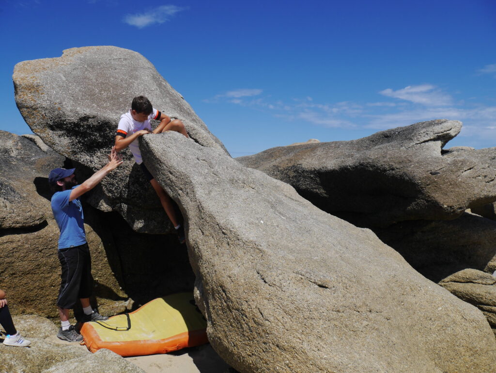
The Rocks : A Playground
The granite blockfield of Meneham features about 4,000 blocs of varying heights, reaching up to 4 metres tall. This is the second largest bouldering spot in France, after that of Fontainebleu, and it is accessible to all.
When climbing in a natural site, a distinction is made between routes and the bloc. The route is often associated with high rock walls of several dozen metres, with ropes and rappelling. Bouldering is carried out on rocks a few metres high, without ropes or harnesses. To prevent any falls, a mat (known as a crash pad) is laid at the foot of the bloc while a spotter keeps an eye on the climber from the ground.
The Meneham site has two peculiarities:
- The granite’s flat, punctuated surfaces sometimes make for elusive holds – a rather interesting challenge!
- Climbs are dictated by the tides, as some rocks are only accessible at low tide.*
The first climbers arrived at Meneham in the 2000s. Bernard Héry and Emgan Querellou set their sights on the blockfield on the foreshore, around the site of Meneham. A few years later, they would open and inventory more than a thousand bouldering passages. At the same time, they initiated Yannick Tissier and his group of Face Ouest enthusiasts.
In 2012, Youenn Letty created the Blokuhaka Festival, a bouldering contest marked by the tides.
Today, blocs continue to be opened in Meneham thanks to Charles Albert, an internationally renowned barefoot climber and sponsor of Blokuhaka since 2016.
Antoine Guignat regularly trains young climbers. In Meneham, he found an ideal playground for the mental development and technical progression of his students. Since 2019, he has also opened a bouldering circuit for beginners which he supervises every day in summer.
We’re sure that Meneham still holds a great many challenges for bouldering enthusiasts!
And if you prefer to admire these giants from below, why not go paddleboarding between them? Or if you want to see what’s underneath the tip of the iceberg, diving is another great option!
*Climbing the rocks on the dune is forbidden in order to preserve the ecosystem and the fragile lichen that grow there.
Men Gaolod (or Men Gaoulou)
GPS coordinates: 48.654566, -4.379724
Two impressive rocks stand against each other, almost forming a pair of rabbit ears. A 16th-century monolithic cross standing 2.5 m high has been erected near this double blockfield. It is located on private property and visible from the « A Dreuz » hiking trails and the community loop.
Legend has it that the Baron of Kerisquillien – owner of the castle of the same name – promised to build a chapel dedicated to the Virgin, in payment for his sins. However, he did not keep his word and so, upon his death, he was condemned to climb one of the rocks of Men Gaolod and jump from one to the other for eternity. It is said that on a full moon, you can see his shadow tottering on the rocks.
Roc’h ar Ghehiel (the Arc de Triomphe)
GPS coordinates: 48.669735, -4.357177
Though it may be reminiscent of a dolmen, this rock is not the result of man’s intervention. It is a natural monument formed by erosion. Located on private property, it is visible from the « Between land and sea » hiking trail.
It is said that once, long ago, a huge stone blocked the way to Lestonquet and Minioc, in Kerlouan. One night, three witches with a fondness for the inhabitants of these two villages brandished their distaffs to lift this rock and place it upon two other blocks. This new gate allowed the inhabitants to travel unimpeded between the two villages.
Roc’h ar Conq
GPS coordinates: 48.658816, -4.390022
Before turning towards the Saint-Egarec chapel, admire the rocky cluster of Roc’h ar Conq – nicknamed « the sleeping monster » – overlooking the dune and the beach.
It is said that one night, during a violent storm, a boat was shipwrecked and crashed on the rocks along the coast of Kerlouan. More than 60 survivors reached the land and took refuge under this rock. Following the shipwreck, this large rock was named « ar conqu » – meaning « shelter », « port » or « cove ».
It is also said that the people of Kerlouan were born under its ear.
Skull rock
GPS coordinates: 48.667131, -4.377804
In Kerlouan, some say that this rock has been here for centuries, protecting the coast and deterring enemy boats from invading the land. Others claim that a pirate once hid his treasure not far from there …
The accomplices, or the petrified lovers
GPS coordinates: 48.676154, -4.351755
This is where a young couple used to meet at nightfall. It is said that, upon discovering their secret night-time escapades, the girl’s father – in a mad rage – turned the two lovers to stone, exposing them to the eyes of all and humiliating them forever more …
Barrachou and the claws of Guissény
Claws of Guissény (GPS coordinates: 48.637751, -4.409095)
A long time ago, an evil creature wandered near the Croaz an Aod calvary in Guissény. Though no signs of life have been detected for many years, rumour has it that it is still out there, roaming … What’s more, as you walk along the beach of La Croix, you’ll discover rocks in strange shapes, like great big claws coming out of the sand … But don’t get too close, passers-by claim to have seen them move!
Barrachou (GPS coordinates: 48.638636, -4.412211)
Just above the dune, you’ll be able to make out three giant monsters standing on the coast. Could that be the backbone of a strange dragon? One thing’s for sure, these colossal rocks take on a multitude of shapes under the changing shadows and lights.
The toads
GPS coordinates: 48.674550, -4.325204
In Plounéour-Brignogan-Plages, the Les Crapauds beach – French for « toads » – is aptly named, and you’ll soon see why!
Legend has it that a priest once travelled to a farm in Brignogan to exorcise a worker suffering from convulsions. After a few exorcism rituals, a rat escaped from the possessed man’s belt. The priest then threw his staff at the rat, which snuck under the door, turned into a rabbit and slipped into a burrow – while the staff transformed into a ferret and set off in pursuit of the rabbit. Once out of the burrow, the rabbit became a hare and the staff a greyhound.
Metamorphoses followed one after the other as this furious race progressed, until the gull swallowed the eel, which suddenly transformed into a toad. In disgust, the gull dropped the toad mid-flight and it crashed onto a stone, swelled up and froze into a solid rock for all eternity. Could this be how a menagerie of hell came to be erected in the Pays Pagan?
Mean ar C’haz, the cat’s rock
GPS coordinates: 48.649439, -4.298632
Near the hamlet of Kerurus in Plounéour-Brignogan-Plages, stand a group of three rocks known as Mean ar C’haz. This solitary rock, emerging from the sand, can be seen every day at low tide.
It is said that one day, a hungry kitten ventured a little too far into the bay and was surprised by a limpet. As he tried to eat it, the limpet reattached itself to the rock, wedging the cat’s paw between itself and the rock! As night fell, the kitten’s meows could be heard echoing through the bay, trying to convince the limpet to let him go:
In Breton
Leh ahanon, me da leho
Pe ar mor bras va beuho
In English
Let me go and I will leave you alone
Or else the ocean will drown me
The daring cat was never seen again, though the rock upon which it perished has borne its name ever since: Mean ar C’haz, the cat’s rock.
The Côte des Légendes bestiary
While exploring the Pays Pagan, you might just come across some extraordinary stone wildlife: elephants, a baboon, a carp, a rhino, a crocodile, a gorilla, an owl, a pigeon, a dog, a mouse, a weasel, a seal, a duck, a rabbit, a raven, a dolphin, a squirrel, turtles, an eagle, a bulldog, a dromedary, a camel, a spaniel, a shark, a bear or even a lion!
Here are some hints to follow the tracks of eight of them:
The carp: 48.668971, -4.372378
The condor: 48.663002, -4.378414
Elephants: 48.665006, -4.386333
The bird: 48.665093, 4.386625
The duck: 48.663073, -4.379766
The rabbit: 48.663025, -4.380586
The turtle: 48.661850, -4.382651
The dromedary: 48.669370, 4.352038
Of course, this list is far from exhaustive as it continues to grow with everyone’s overflowing imaginations!